190 million years of waiting
The Wave, Arizona: how the ancient dunes of Pangaea became the most difficult natural landmark to access in North America - and why that may be exactly how it should be.
Every day, thousands of people visit the website of the U.S. Bureau of Land Management and click Apply. Most of them are rejected.
They are trying to reach a patch of sandstone roughly the size of a tennis court.
That is not an exaggeration. The main trough of The Wave measures about thirty-six meters long and nineteen meters wide. A relatively small section of rippling stone hidden in the desert along the Arizona-Utah border - and one that hundreds of thousands of people attempt to visit every year, despite the fact that only sixty-four visitors per day are officially allowed inside.
But before talking about the lottery, it is important to understand what people are actually trying to see.
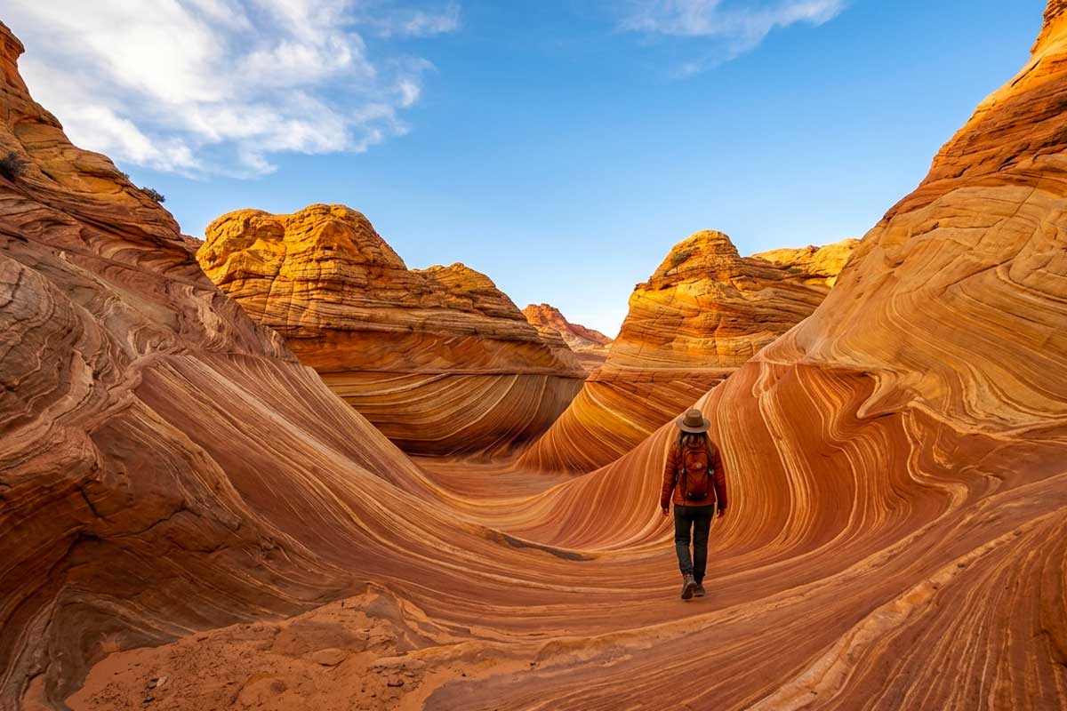
Because The Wave is difficult to explain in words. It is a stone ocean frozen in motion. Layers of red, orange, honey, white, pink, and violet sandstone roll across one another in endless movement, as if the surface is still flowing. And all of this exists in the middle of a dry desert landscape without rivers, trees, or landmarks, exposed beneath an open sky.
Pangaea, the ancient Appalachians, and the largest sand sea in Earth’s history
The story of The Wave begins about 190 million years ago, during the Jurassic period.
The Earth looked very different then. The continents were only beginning to separate after the existence of the supercontinent Pangaea. What is now Arizona and Utah was once covered by a gigantic erg - an immense sea of shifting sand dunes. Geologists believe it was one of the largest deserts in the known geological history of the planet. Some dunes may have reached the height of modern skyscrapers.
The most surprising part is where the sand came from.
It originated in the east, from the ancient mountain range known as the Ancestral Appalachians, which at the time were dramatically taller than today’s Appalachian Mountains. Rivers carried sediment across Pangaea, while winds lifted the dried sand and transported it back south and southwest, building giant dunes layer upon layer.
Over time, those dunes were buried beneath new sediments. Pressure and chemical processes transformed loose sand into stone. This eventually formed the Navajo Sandstone formation - one of the most recognizable geological layers of the American Southwest.
Later, erosion stripped away the upper layers and exposed the ancient dunes once again. Inside the rock, cross-bedding patterns still preserve the direction of Jurassic winds. At The Wave, these formations are exposed so clearly that visitors can literally trace the movement of prehistoric air currents across the stone with their hands.
Why The Wave looks unreal
The colors of The Wave are the result of geochemistry, not digital editing.
Red and orange tones come from oxidized iron. White sections formed where ancient groundwater washed minerals away. Yellow, lavender, beige, and cream-colored bands appeared through complex chemical reactions involving iron, manganese, and silica inside the porous sandstone.
Geochemists refer to many of these repeating patterns as Liesegang rings, named after German chemist Raphael Liesegang, who described similar formations in the nineteenth century. Nature arrived at the same result through millions of years and billions of tons of stone.
The most important detail is that the colors never look exactly the same twice.
Morning light gives the sandstone an almost metallic glow. Midday sun flattens the contrast. Near sunset, the rock becomes copper-like and intensely warm. Professional photographers often plan entire trips around seasonal lighting conditions - and spend years trying to win the lottery for the right date.
A wave carved by wind
The Wave consists of two intersecting U-shaped sandstone troughs.
They originally began forming through water erosion as rainfall flowed through cracks in the rock. But over time, the drainage basin changed, and wind became the dominant sculpting force.
As air passes through the narrow stone channels, it accelerates through what physicists call the Venturi effect. Faster-moving air carries more sand particles, which grind and polish the walls like natural sandpaper.
If you examine the surfaces carefully, you can still see evidence of changing wind directions - subtle ridges and contours preserved across thousands of years.
The Wave is not just a rock formation.
It is a fossilized recording of wind itself.
How German photographers “discovered” The Wave
It is difficult to imagine today, but thirty years ago this place was virtually unknown outside geological circles.
Until the early 1990s, The Wave remained an obscure section of federal land visited mostly by geologists and local rangers.
Everything changed when German landscape photography magazines began publishing images of the site. In 1996, The Wave appeared in the German documentary “Faszination Natur,” and international interest exploded soon afterward.
Ironically, it was not Americans who introduced The Wave to the global travel world.
It was photographers.
By the late 1990s, visitor demand had become so intense that the Bureau of Land Management introduced strict permit limits. Initially only twenty people per day were allowed access. In 2021, after years of debate balancing preservation and accessibility, the limit was raised to sixty-four visitors daily.
Sixty-four people.
Fewer than the capacity of a standard school bus.
The mathematics of an almost impossible lottery
Today the system works like this.
Forty-eight permits are distributed through an advance lottery on recreation.gov, with applications submitted four months ahead of the desired date. Another sixteen permits are distributed through a daily lottery held two days before entry, available only to applicants physically located near Kanab, Utah, or Page, Arizona.
The application fee is nine dollars per person and non-refundable. Winning applicants then pay an additional permit fee.
During peak seasons, the odds of success are often only a few percent.
Entering without a permit is illegal. Fines can reach five hundred dollars, and rangers patrol the area regularly.
There is also no official marked trail. No signs. No fencing. No visitor infrastructure. Permit holders receive GPS coordinates and navigate roughly six kilometers each way across open desert from the Wire Pass Trailhead parking area.
Summer temperatures regularly exceed forty degrees Celsius. There is no shade and no nearby water source. Navigation mistakes happen every year.
The restrictions exist not only to protect the landscape - but to protect visitors themselves.
What it feels like inside
Almost everyone who enters The Wave describes the same thing first: silence.
Above you is nothing but sky. Beneath your feet is stone that looks painted by hand. No roads. No buildings. No sounds of civilization. The six kilometers of desert behind you erase everything unnecessary.
Photographers often describe a strange sense of disorientation: it becomes impossible to decide where to look because every direction feels extraordinary. The sandstone beneath your boots is often as mesmerizing as the famous curves ahead.
Most visitors spend between three and six hours exploring the area, simply watching how the light transforms the rock.
And beyond the main formation lies an entire landscape of additional wonders within Coyote Buttes North: the Second Wave, Melody Arch, Top Rock Arch, and other surreal sandstone formations. Travelers who prepare carefully usually explore far beyond the famous Instagram frame.
White Pocket: the alternative that is not really second-best
About twenty-five kilometers away lies White Pocket, often described as “The Wave without the lottery.”
It is not a copy. White Pocket has a completely different personality.
Instead of smooth flowing bands, the landscape resembles twisted fabric, folded paper, or frozen waves of cream-colored stone. White, red, and orange sandstone blend together in combinations unlike almost anywhere else in North America.
No permit is required. But a serious four-wheel-drive vehicle is essential, as the final section crosses deep soft sand where ordinary cars routinely become trapped.
For many travelers, White Pocket becomes not a backup plan - but a destination in its own right.
Why the restrictions make sense
It took 190 million years for the dunes of Jurassic Pangaea to become what we now call The Wave.
Only sixty-four people per day are allowed to see it in person.
There is a certain fairness in the fact that access to a place older than human civilization itself cannot be guaranteed by money, status, or early planning.
Only by chance.
Geology is indifferent to human beings. And perhaps that is exactly why The Wave still feels as though it was created not for us - but despite us.